April 7-13, 2025
Iowa Secretary of Agriculture Mike Naig commented on the Iowa Crop Progress and Condition Report released by the USDA National Agricultural Statistics Service. The report is released weekly April through November. Additionally, the Iowa Department of Agriculture and Land Stewardship provides a weather summary each week during this time.
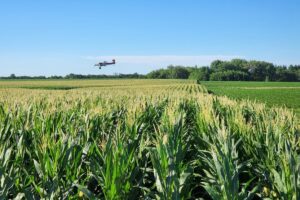
“Planters are beginning to roll across the state. The warmer temperatures and drier weather over the past week allowed for a good start to the planting season,” said Secretary Naig. “Outlooks for the rest of April are showing better chances for rain and a more active weather pattern. The threat of severe weather is elevated this time of year, so I encourage all Iowans to be weather aware and have a safety plan in place.”
The weekly report is also available on the USDA’s website at nass.usda.gov.
Crop Report
Dry conditions helped Iowa farmers as days suitable for fieldwork increased to 5.9 for the week ending April 13, 2025, according to the USDA, National Agricultural Statistics Service. Fieldwork included tillage, seeding oats, and applying anhydrous, manure and dry fertilizer. There were also reports of corn and soybeans being planted.
Topsoil moisture condition rated 7 percent very short, 24 percent short, 68 percent adequate and 1 percent surplus. Subsoil moisture condition rated 9 percent very short, 31 percent short, 59 percent adequate and 1 percent surplus.
Oats seeding reached 47 percent complete, 3 days behind last year but 3 days ahead of the 5-year average. Six percent of the expected oat acreage has emerged, 5 days behind last year but equal to the average.
No livestock issues were reported.
Weather Summary
Provided by Justin Glisan, Ph.D., State Climatologist, Iowa Department of Agriculture and Land Stewardship
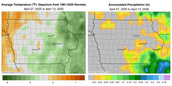
A drier pattern prevailed through the reporting period with most of Iowa’s weather stations reporting no rainfall; southeastern Iowa observed the wettest conditions. Weekly temperatures varied from nearly four degrees above normal in northwest Iowa to a few degrees below average farther east; Iowa’s average temperature was 45.2 degrees, 1.0 degree below normal.
Westerly winds persisted through Sunday (6th) afternoon as daytime temperatures settled in the mid to upper 50s across much of Iowa. Winds shifted to a northerly direction overnight as a weak cold front dropped southeast through the state. Monday (7th) morning lows remained in the upper 30s over southeastern Iowa while low 20s were recorded northwest with clear skies statewide. Daytime highs were unseasonably cold, holding in the upper 30s to mid 40s, with gusty winds and sunshine. Tuesday (8th) dawned frigid across portions of Iowa with low temperatures in the teens to low 20s; the statewide average low was 21 degrees, 13 degrees below normal. Winds swung around to the south through the day, helping boost temperatures into the mid to upper 50s in western Iowa; conditions were several degrees cooler in eastern Iowa where high-level haze was reported. Clouds increased over southern Iowa after midnight as a low pressure system skirted the Iowa-Missouri border. Very light rain was reported in southeastern Iowa with a handful of stations collecting a trace; a 0.01-inch measurement was taken in Donnellson (Lee County) and Yarmouth (Des Moines County) at 7:00 am on Wednesday (9th). Temperatures rose into the upper 60s and low 70s in western Iowa through the day as scattered showers formed on the backside of the disturbance in eastern Iowa. Rain totals were under a tenth of an inch for all stations reporting measurable amounts.
Cloudy skies developed into Thursday (10th) morning with patchy fog in eastern Iowa, where temperatures were in the mid 30s; lows across the state were in the upper 40s and low 50s. The atmosphere over southeastern Iowa became unsettled through the afternoon hours, allowing scattered thundershowers to pop up. These cells moved from northwest to southeast, producing some moderate rainfall accumulations; Salem (Henry County) observed 0.17 inch while Morning Sun (Louisa County) reported the week’s highest total of 0.39 inch. High pressure built in across the Upper Midwest as clouds cleared western Iowa into Friday (11th). Hazy conditions and poor air quality were reported as temperatures rose into the upper 50s and low 60s from east to west. Cloudless skies persisted overnight and through Saturday (12th) with strong southerly winds and daytime temperatures from the low 60s in southeastern Iowa to upper 70s and a few low 80s over the state’s western extent. Gusty winds held on into early Sunday (13th) morning with spotty clouds and readings in the 50s statewide.
The statewide weekly average precipitation was 0.02 inch while the normal is 0.79 inch. Little Sioux (Harrison County) reported the week’s high temperature of 82 degrees on the 12th, 21 degrees above average. Elkader (Clayton County) reported the week’s low temperature of 13 degrees on the 8th, 18 degrees below normal. Four-inch soil temperatures were in the upper 40s northeast to upper 50s southwest as of Sunday.
***Courtesy of the Iowa Department of Agriculture and Land Stewardship***